-
 Zverev reaches ATP Finals last four, Alcaraz on brink of exit
-
Lebanon rescuer picks up 'pieces' of father after Israel strike

-
 US retail sales lose steam in October after hurricanes
-
Zverev reaches ATP Finals last four with set win against Alcaraz

-
 Kerevi back for Australia against Wales, Suaalii on bench
-
Spate of child poisoning deaths sparks S.Africa xenophobia

-
 Comedian Conan O'Brien to host Oscars
-
Rozner overtakes McIlroy and Hatton for Dubai lead

-
 Mourners bid farewell to medic killed in east Ukraine
-
Gore says 'absurd' to hold UN climate talks in petrostates

-
 Hamas says 'ready for ceasefire' as Israel presses Gaza campaign
-
Amorim says Man Utd is 'where I'm supposed to be'

-
 Japan hammer Indonesia to edge closer to World Cup spot
-
Jeff Beck guitar collection to go under the hammer in January

-
 Veteran Ranieri has 'no time for mistakes' on Roma return
-
Van Nistelrooy says he will 'cherish' Man Utd memories in farewell message

-
 IAEA chief tours sensitive Iran nuclear plants
-
Pompeii rejects 'mass tourism' with daily visitor limit

-
 Jailed Russian poet could be 'killed' in prison, warns wife
-
French court orders release of Lebanese militant held since 1984

-
 Global stocks struggle after Fed signals slower rate cuts
-
UK economy slows, hitting government growth plans

-
 Primary schools empty as smog persists in Indian capital
-
Palestinians turn to local soda in boycott of Israel-linked goods

-
 Typhoon Man-yi bears down on Philippines still reeling from Usagi
-
UK growth slows in third quarter, dealing blow to Labour government

-
 Chris Wood hits quickfire double in NZ World Cup qualifying romp
-
Markets struggle at end of tough week

-
 China tests building Moon base with lunar soil bricks
-
Film's 'search for Palestine' takes centre stage at Cairo festival

-
 Oil execs work COP29 as NGOs slam lobbyist presence
-
Gore says climate progress 'won't slow much' because of Trump

-
 'Megaquake' warning hits Japan's growth
-
Stiff business: Berlin startup will freeze your corpse for monthly fee

-
 Wars, looming Trump reign set to dominate G20 summit
-
Xi, Biden attend Asia-Pacific summit, prepare to meet

-
 Kyrgios to make competitive return at Brisbane next month after injuries
-
Dominican Juan Luis Guerra triumphs at 25th annual Latin Grammys

-
 Landslide win for Sri Lanka president's leftist coalition in snap polls
-
Australian World Cup penalty hero Vine takes mental health break

-
 As Philippines picks up from Usagi, a fresh storm bears down
-
Tropical Storm Sara pounds Honduras with heavy rain

-
 Pepi gives Pochettino win for USA in Jamaica
-
'Hell to heaven' as China reignite World Cup hopes with late winner

-
 Rebel attacks keep Indian-run Kashmir on the boil
-
New Zealand challenge 'immense but fantastic' for France

-
 Under pressure England boss Borthwick in Springboks' spotlight
-
All Blacks plan to nullify 'freakish' Dupont, says Lienert-Brown

-
 TikTok makes AI driven ad tool available globally
-
Japan growth slows as new PM readies stimulus


Monster Hurricane Ian hammers Florida
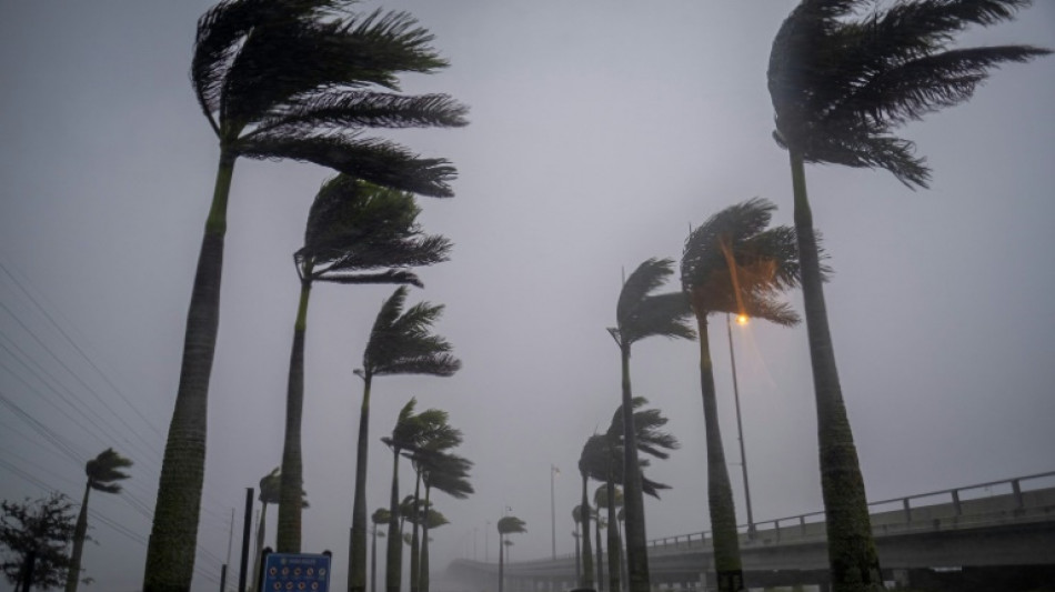
Heavy winds and rain pummelled Florida on Wednesday as Hurricane Ian intensified to just shy of the strongest Category 5 level, threatening to wreak "catastrophic" destruction on the southern US state.
Forecasters warned of a looming once-in-a-generation calamity, with life-threatening storm surges, extensive flooding and devastating winds promising what Florida Governor Ron DeSantis called a "nasty" natural disaster.
The National Hurricane Center (NHC) said in its latest advisory that the "extremely dangerous eyewall of Ian (was) moving onshore" and bringing sustained winds of 155 miles (250 kilometers) per hour, just two mph shy of Category 5 intensity -- the strongest category on the Saffir-Simpson scale.
Some 2.5 million people were under mandatory evacuation orders in a dozen coastal Florida counties, with voluntary evacuation recommended in several others.
With the golden hour to flee having past -- and hurricane force winds nearly touching southwestern Florida -- authorities were advising residents to hunker down and stay indoors.
"Ian has strengthened into an extremely dangerous Category 4 hurricane," the NHC said, warning of "catastrophic storm surge, winds, and flooding."
Airports in Tampa and Orlando stopped all commercial flights, and some 337,000 households were already without power.
"This is going to be a nasty, nasty day, two days," DeSantis said.
"It could make landfall as a Category 5, but clearly this is a very powerful major hurricane that's going to have major impacts."
With conditions rapidly deteriorating, some thrill-seekers were seen walking in the mud flats of Tampa Bay and in Charlotte Harbor, further south, ahead of Ian's arrival.
The storm was expected to roar ashore in the coming hours near Fort Myers and Port Charlotte, along the state's west coast, before moving across central Florida and emerging in the Atlantic Ocean by late Thursday.
With up to two feet (61 centimeters) of rain expected to fall on parts of the so-called Sunshine State, and a storm surge that could reach devastating levels of 12 to 18 feet (3.6 to 5.5 meters) above ground, authorities were warning of dire emergency conditions.
"This is a life-threatening situation," the NHC warned.
- Widespread blackout -
Ian a day earlier had plunged all of Cuba into darkness after battering the country's west as a Category 3 for more than five hours before moving back out over the Gulf of Mexico.
The storm damaged Cuba's power network and left the island "without electrical service," state electricity company Union Electrica said.
Only the few people with gasoline-powered generators had electricity on the island of more than 11 million people.
Others had to make do with flashlights or candles at home, and lit their way with cell phones as they walked the streets.
"Desolation and destruction. These are terrifying hours. Nothing is left here," a 70-year-old resident of the western city of Pinar del Rio was quoted as saying in a social media post by his journalist son, Lazaro Manuel Alonso.
At least two people died in Pinar del Rio province, Cuban state media reported.
- 'Historic event' -
In the United States, the Pentagon said 3,200 national guardsmen had been called up in Florida, with another 1,800 on the way.
FEMA (Federal Emergency Management Agency) administrator Deanne Criswell warned that Ian's "painful impacts" were being felt even before the hurricane's landfall.
National Weather Service director Ken Graham echoed concerns about what lies ahead, expressing certainty Ian will leave a trail of destruction.
"This is going to be a storm we talk about for many years to come," he said. "It's a historic event."
As climate change warms the ocean's surface, the number of powerful tropical storms, or cyclones, with stronger winds and more precipitation is likely to increase.
The total number of cyclones, however, may not.
According to Gary Lackmann, a professor of atmospheric science at North Carolina State University, studies have also detected a "potential link" between climate change and what is known as rapid intensification -- when a relatively weak tropical storm surges to a Category 3 hurricane or higher in a 24-hour period, as happened with Ian.
"There remains a consensus that there will be fewer storms, but that the strongest will get stronger," Lackmann told AFP.
O.Brown--AT

